


In the latest installment of the “how can a self-proclaimed progressive city council enrich a developer to the detriment of the environment and the community’s well-being”, City of Lakewood is allowing a developer to push forward with a development which will significantly increase traffic on a major thoroughfare, further strain our environment, potentially expose the future residents to toxic hazards AND, again, bring no meaningful economic development to the city.
Lincoln Properties (or is it Royal Lakewood Land Partners?) has made a submission for a development called “The Bend”, situated on the NW corner of the Federal Center, close to the intersection of the 4th Avenue and Union Boulevard, and, just a hop and a skip away from the off and the on-ramp from the 6th Avenue.
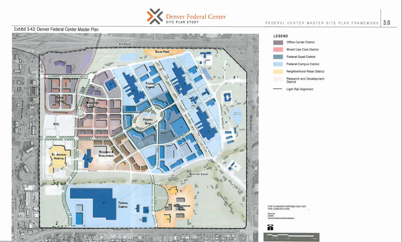
To add the insult to the many more injuries to come, as shown in the 2007 Master Plan, the site was originally slated for Office Development – a perfect potential use, considering the proximity of the LightRail tracks and the dire need for this city to stoke actual economic development.
As usually is the case, the math does not add up. The developer is using the tactic of “here is a traffic study… but it’s only for a part of the development, but we won’t even tell you how many poor souls we want to stuff in to these chicken coops. Then they talk about how this will “hardly” affect traffic, etc.
By the time the locals realize just how badly it will have screwed them, the city council and the bureaucrats, who had enabled this environmental and economic disaster, will have moved on to something else, such as being a State Representative, where they continue to shill for the developer profit (ahem, Rebecca Stewart).
So, lets see if 2 + 2 equals 4, or, maybe, 17, or maybe a dumpster fire for decades to come. Who knows. The math is very political-contribution-size-dependent these days.
Lets look at some of the documents in the submission provided by the developer.
01 - The Bend Minor Subdivision Plat - ALTA – 10.02.2024
There are Environmental Use Restriction in the Northern Part of the plat – what does that mean? City of Lakewood (and the state of Colorado) have shown that they will not step in and provide additional protections for those affected by the potential toxic exposure in the case of Terumo BCT. So, who would ensure that anyone living in this development in the future is not exposed to toxins the effects of which may not materialize for decades? Who will be held responsible a decade or two down the road?
01 - The Bend Minor Subdivision Plat - Traffic Study_2024-10-10
There are only details show for the Southern part of the plat – what about the Northern part of the plat? This is where the math gets hazy, quick. A tactic of piece-mealing the development plans is frequently used (just as is the case with the development near Belmar) to, lets say, omit, the actual impact of the additional car-travel-per-day numbers on the area surrounding the development. Not only will this adversely impact the surrounding area, but also add to the already high total of vehicles having to travel out of Lakewood, since Lakewood has failed to attract localized, high-tech, well-paying employment.
Just as with the development on other side of the Green Mountain, at Indiana and Alameda, by 470, the development will create an impingement/higher-risk situation from an arterial street feeding in to another major arterial street shortly before/after an off-ramp/on-ramp to a major state highway.
In the case of Red Rocks/Solterra, Indiana dumps out on to Alameda right as vehicle come off the off-ramp from 470. Here, there is a potential for a major choke point from 4th dumping people on to Union, right as people are about to merge to the on-ramp to 6th (and people coming from the off-ramp on the other side of Union). That area is already a bottle-neck and will get exponentially worse. This is a problem not only from the traffic perspective, but also a much bigger problem in the case where an evacuation (i.e. safety of the public at large) is needed.
The city seems to be willfully approving the degradation of any additional capacity which might be needed in case of an emergency and the already overloaded flow of a major thoroughfare to a state highway. In additional to approving the destruction of the original development master plan, meant to stoke localized job creation.

02 - The Bend Minor Subdivision Plat - Final Drainage Report
Pages 5 and 6
“Proposed Project Description
The proposed development (the "Site") is anticipated to consist of multiple phases. The infrastructure improvements are the first phase in a multi-phase mixed-use development on the Site. This report will describe the improvements proposed as a part of the initial infrastructure loop and the improvements along 4th Avenue, Union Boulevard, and the West 6th Avenue off-ramp onto Union Boulevard.
Additionally, the overall developer will mass grade the site south of 4th avenue, install private drives, and utility mains across the site which will have an assumed imperviousness for future development.
The area North of 4th Avenue is not to be modified per this report and will remain as existing. This area will be developed as a part of a future phase and any additional detention or water quality needs due to additional development will be evaluated at that time. The north parcel phases of the Project will likely consist of multifamily apartments, commercial shopping, amenities with associated site parking, and utility installation.”
So can you or can you not disturb the soil on top of a contaminated plot of land? And, again, HOW MANY actual daily trips will spill out on to the Union Boulevard, blocking an already-overloaded major thoroughfare? How much more air pollution?
02 - The Bend Minor Subdivision Plat - Final Pavement Design Report
“Page 5:
Union Boulevard
Union Boulevard is considered an Arterial Street. We understand that the current traffic count for Union Boulevard is 52,000 vehicles per day north of West 4th Avenue and 35,000 vehicles per day south of West 4th Avenue. These are expected to increase to 57,000 and 39,000 vehicles per day in the next 20 years. Assuming about 2 percent of the traffic consists of heavy trucks, and that traffic is divided equally between the lanes. this translates to an ESAL loading of 2.86 million.
West 4th Avenue
West 4th Avenue will be considered a Collector Street, once completed. The estimated traffic that will be supported by West 4th Avenue is 13,000 vehicles per day, growing to 14,000 vehicles per day in 20 years. Again, assuming 2 percent of these vehicles will consist of heavy trucks, a traffic volume of 715,000 ESALs is applicable.
Private Streets
Based upon the nature and size of the development, we estimate that the streets internal to the site boundaries will be considered Local Streets. We estimate that they will support a traffic load of about 2,000 vehicles a day with less than 1 percent heavy trucks. This yields a traffic volume of 23,000 ESALs for a 20-year design life.”
You should be getting the point by now. Since the above engineering speak only covers half (potentially, less than half), what will this do to the actual traffic load on Union and for those traveling to and from other parts of the city via Union and the 6th Avenue?
Simple math says that: (57000 - 52000) / 52000 = 0.1 (that’s 10%) increase in traffic, JUST from this phase.
02 - The Bend Minor Subdivision Plat - Phase I Environmental Study Assessment
Page 8:
Remediation activities including the excavation and disposal of site-wide surficial impacted soils and isolated areas of impacted subsurface soils were considered sufficient by CDPHE and several No Further Action (NFA) letters were issued by CDPHE for the IAs. However, based on various documents reviewed and brief discussion with CDPHE regarding the property, residual contamination was left in place and covered with a clean cap layer to prevent exposure from impacted soils. Additionally, institutional controls was placed on the subject property that restricted use of the land and included the following: 1) in the Northwest Corner Landfill Cover (discussed below), no soil disturbing activities are permitted and the subject property owner is required to monitor and maintain corrective measures; and 2) the entire subject property has a use restriction for groundwater that includes groundwater to a depth of 100 feet below ground surface (bgs) cannot be withdrawn due to PAH contamination and if the owner is not the federal government, a construction dewatering permit in accordance with the Colorado Water Quality Control Act must be obtained and Water Quality Control Division (WQCD) must be notified of the restricted use. The institutional controls for the subject property are considered to be CRECs…
Ask you local government as to WHY has the city failed to stoke any meaningful local economic development and keeps enabling more developer profit to the detriment to the whole city? And what does the above mean? Is the site safe or is it only safe insofar as “we said it’s safe enough, so sure, it’s safe”?
02 - The Bend Minor Subdivision Plat - Traffic Study
For the purposes of this analysis, the project is anticipated to include approximately 2,356 multifamily units and 131,000 square feet of retail uses among two development areas split on the north and south sides of 4th Avenue.
So… Is it “only” about 2000 units or will there be more? Because selling a development to the public based on the “well, maybe it will double or triple later” is not being fully transparent and forthcoming, when estimating the actual impacts on the traffic, environment and the well-being of the residents current and future.